Formats
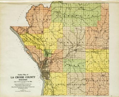
Resources
—Maps—
Author:
W. W. Hixson and Co.
Creator:
W. W. Hixson and Co.
Description:
Plat book of La Crosse County, Wisconsin, 1930 which includes rural landowners
Author:
La Crosse Tribune
Creator:
Kenyon Company
Description:
Plat book of La Crosse County, Wisconsin, for 1913, showing rural landowners.
Author:
La Crosse Building Trades
Description:
Concept approval La Crosse Common Council, La Crosse County Board. Shows a proposal for the Bicentennial Expressway including key businesses. No scale given.
Map / on sheet 90 x 59 cm. / Black and white
Map / on sheet 90 x 59 cm. / Black and white
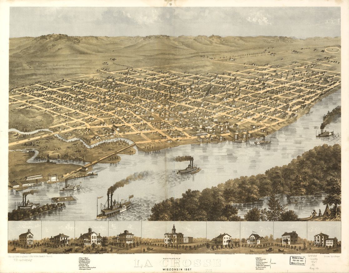
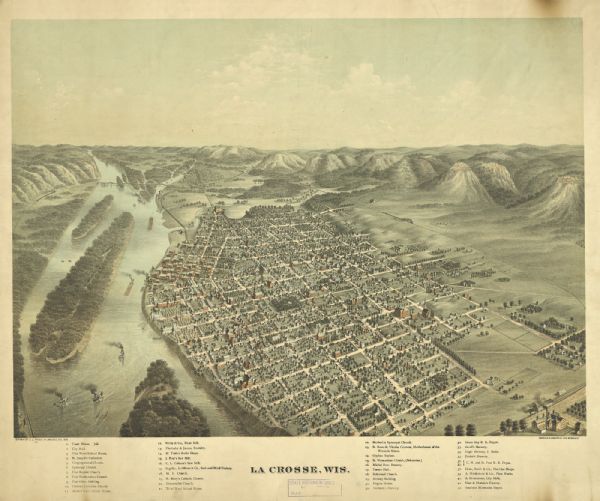
Author:
Chicago Lithographing Co.
Creator:
A. Ruger
Description:
Perspective map not drawn to scale. LC Panoramic maps (2nd ed.), 1036 Available also through the Library of Congress Web site as a raster image. Includes illus. and index to points of interest.
Part of the Library of Congress Geography and Map Division
Part of the Library of Congress Geography and Map Division
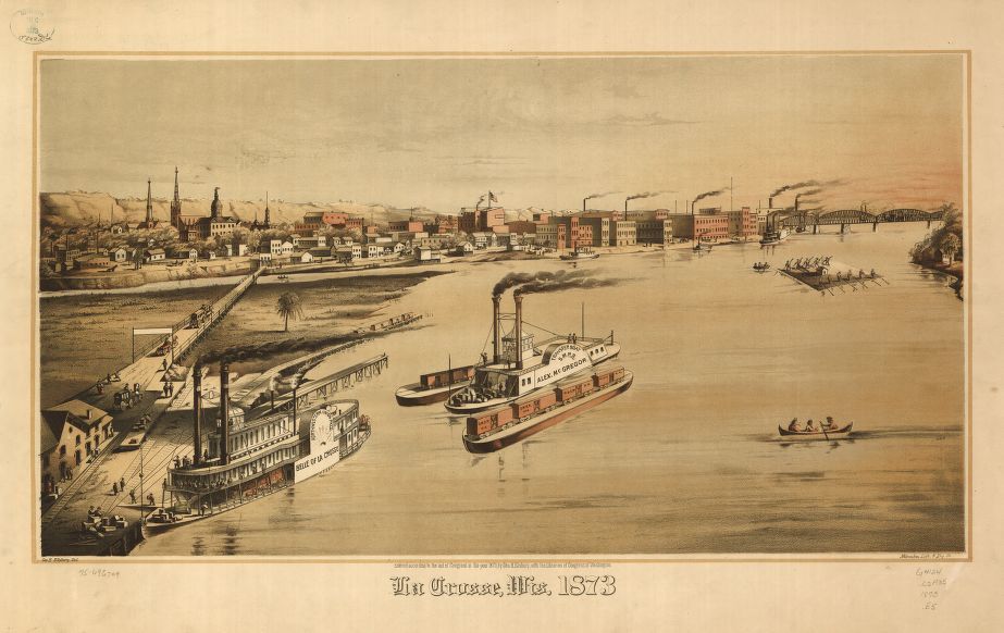
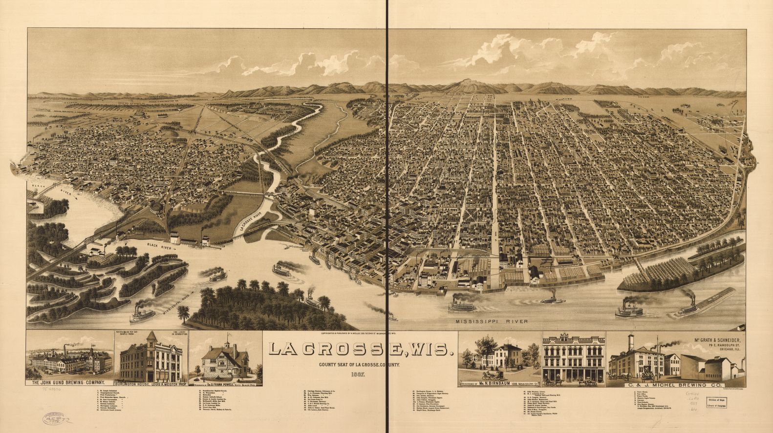
Author:
Milwaukee Lithography and Engraving Co.
Creator:
George H. Ellsbury
Description:
Perspective map not drawn to scale. LC Panoramic maps (2nd ed.), 1037 Available also through the Library of Congress Web site as a raster image.
Part of Library of Congress Geography and Map Division
Part of Library of Congress Geography and Map Division
Creator:
C. J. Pauli
Description:
Perspective map not drawn to scale
Author:
Beck & Pauli
Creator:
Henry Wellge
Description:
Perspective map not drawn to scale. LC Panoramic maps (2nd ed.), 1038. Available also through the Library of Congress Web site as a raster image. Includes illus. and index to points of interest.
Part of Library of Congress Geography and Map Division
Part of Library of Congress Geography and Map Division
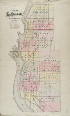
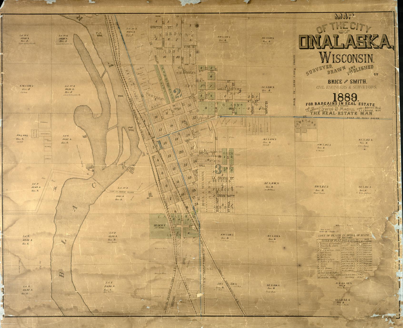
Author:
H. J. Biddenback
Creator:
H. J. Biddenback
Description:
Includes a La Crosse county map and a table of contents listing subdivisions. An overall map shows ward boundaries. Shows schools, cemeteries, parks, rivers, bridges, depots, public buildings, public landings, public squares, churches, synagogue, Mississippi River, La Crosse River (old and new channels), Black River, railroads, roundhouses, housing subdivisions and additions, block and lot numbers, basic building shapes, land owners of unplatted lands in the city borders, lumber yards and sawmills.
Author:
City Engineers Department
Creator:
La Crosse (Wis.). City Engineers Department
Description:
Revised September 1968. Includes index of streets. Shows city streets. Also shows railroads, Municipal Airport, rivers, sloughs, parks, cemeteries, La Crosse County Country Club, municipal harbor, County Infirmary
Scale 1:19,200; 1 inch = 1,600 feet
Map / 86 x 41 cm. on sheet 88 x 46 cm. / black and white
Map / 86 x 41 cm. on sheet 88 x 46 cm. / black and white
Author:
John Nolen
Description:
This map was part of a 1911 report by John Nolen (Making of a park system in La Crosse) on the creation of La Crosse’s park system. The map shows suggested parks and parkways in green. Scale 1:31,680; 1 inch = 1/2 mile
Map / 46 x 31 cm on sheet 53 x 38 cm / Color
Map / 46 x 31 cm on sheet 53 x 38 cm / Color
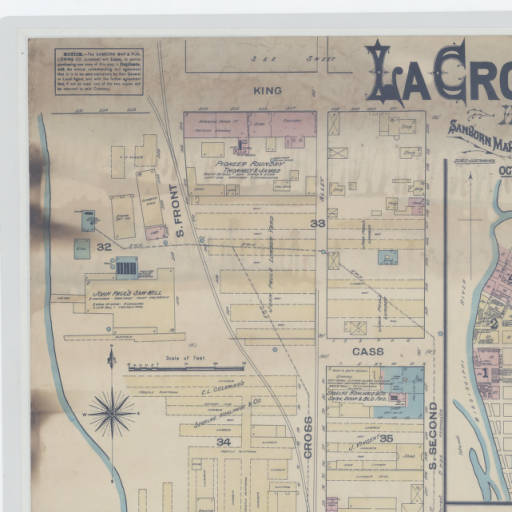
Description:
Sanborn Fire Insurance maps are meticulously detailed, large-scale lithographed, color-keyed street maps. Sanborn Maps helped insurance agents in the late 19th and early 20th centuries determine the degree of fire hazard associated with a particular property. Sanborn Fire Insurance maps typically focus on the business districts within communities. Features include street names, street and sidewalk widths, property boundaries, locations of fire hydrants, locations of water and gas mains, and the names of most public buildings, churches and companies. The maps also document the strength of the local fire department and the presence of fire hazards such as blacksmith forges, large baker's ovens or stored kerosene, and the existence of firefighting equipment, cisterns or community water works. Rivers, canals, railroad corridors and similar features are also noted. Each map provides a detailed assessment of the buildings within a district. Assessments include an outline of each building and outbuilding, the size and number of stories of every building, the location of windows and doors, fire walls, and indications of sprinkler systems. They note the nature of the business or businesses which occupied individual buildings, sometimes even particular room uses. They list the type of construction and the composition of building materials including the framing, flooring, and roofing materials.
Author:
Wisconsin Conservation Department
Creator:
Wisconsin. Conservation Department. Park Planning Section
Description:
Shows Goose Island Park and plans for its development. Sheet 1 of 2. Drawn by Hugh Dega, Checked by Paul Barnhill, approved by R. D. Espeseth, drawing number 100-66. 5-27-60 Scale 1:3,600; 1 inch = 300 feet
Map / 84 x 107 cm / Black and white
Map / 84 x 107 cm / Black and white
Author:
County Highway Commissioner
Creator:
La Crosse County, Wisconsin. Highway Department
Description:
Original drawing made from United States aerial Survey, 1938. Drawn by Birkness and Goddard, 1938. Revised and checked by Paul A. Hartwig C. H., December 1952. Shows United States, state, county and town roads indicating the pavement surface, federal aid secondary roads, townships, towns, coulees, ridges, valleys. county forest preserves, parks, schools, cemeteries, town halls, creeks, rivers, railroads, churches, some development additions
Council Bay, Boy Scout Camp, Girl Scout Camp, Hoeth Forest, United States Government Airway Radio Station, Maple Shade, County Highway Shop, County Asylum, Hylandale Academy, United States Soil Erosion Farm, County Infirmary additions
Scale 1:63,360; 1 inch = 1 mile
Map / 73 x 70 cm / Black and white
Map / 73 x 70 cm / Black and white
Author:
County Highway Commissioner
Creator:
La Crosse (Wis.). Highway Department
Description:
Original drawing made from United States aerial Survey, 1938. Drawn by Birkness and Goddard, 1938. Revised and checked January 1971. Shows United States, state, county and town roads indicating the pavement surface, federal aid secondary roads, townships, towns, coulees, ridges, valleys, county forest preserves, parks, schools, cemeteries, town halls, creeks, rivers, railroads, churches, some development additions. Council Bay, Boy Scout Camp, Girl Scout Camp, Hoeth Forest, United States Government Airway Radio Station, Maple Shade, WHLA Radio Tower, County Highway Shop, La Crosse County Mental Hospital, Hylandale Academy, WSTF Radio Tower, United States Soil Erosion Farm, County Infirmary, Maple Grove. Scale 1:63,360; 1 inch= 1 mile
Map / 73 x 70 cm / Black and white
Map / 73 x 70 cm / Black and white
Author:
Joseph N. Nicollet
Description:
map from An atlas of early maps of the Midwest. Reproductions of maps produced 1678-1856, compiled by W. Raymond Wood, 1983
Author:
Department of Agriculture, Soil Conservation Service
Creator:
United States. Soil Conservation Service
United States. Department of Agriculture
Important farmlands
United States. Department of Agriculture
Important farmlands
Description:
Universal Transverse Mercator projection, 1927, North American datum. September 1977. Indexed. Interpretations derived from soil map constructed 1960 by Cartographic Division, Soil Conservation Service, United States Department of Agriculture, of La Crosse County, Wisconsin. Shows prime farmland, unique farmland other than prime, additional farmland of statewide importance, urban and built-up areas, water areas as well as towns, major roads, sandpits, rivers, lakes, creeks, quarries, valleys, bluffs, radio towers, railroads, landing fields, Coulee State Experimental Forest, La Crosse Municipal Airport, Lock and Dam Number 7, coulees, ridges
Scale 1:100,000; 1 cm = 1 km
Map / 66 x 51 cm / Color
Map / 66 x 51 cm / Color
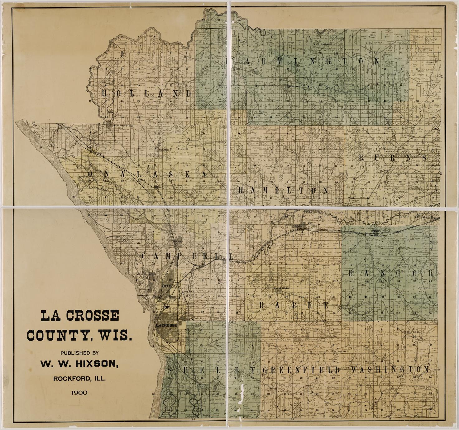
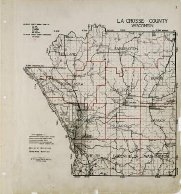
Author:
W. W. Hixson
Creator:
W. W. Hixson
Description:
Shows townships, section numbers and rural landowners names, rivers, and roads.
From the Wisconsin Historical Society collection
From the Wisconsin Historical Society collection
Author:
Hixon Forest Nature Center?
Description:
map of the nature trail system in the La Crosse River marsh and Hixon Forest connecting parks; trails are also rated for difficulty
Author:
John Nolen
Description:
One in a series of maps created by John Nolen, landscape architect and urban planner. Proposed residential, retail business, wholesale business, and industrial properties shown in color. Plan number 34. Map shows existing and proposed streets, street car lines, parks and playgrounds, school grounds, public and semi public areas, cemeteries, railroads, railroad stations, hospitals, fire stations, court house, post office, library, county jail, Inter State Fair Grounds, La Crosse Country Club, pumping station, Wells Water Works. Scale 1:9600; 1 inch = 800 feet
Map / Manuscript / 98 x 65 cm. on sheet 115 x 85 cm.
Map / Manuscript / 98 x 65 cm. on sheet 115 x 85 cm.
Author:
John Nolen
Description:
One in a series of maps created by John Nolen, landscape architect and urban planner. Population figures for each ward shown in red. Plan number 32. Map shows existing and proposed streets, street car lines, parks and playgrounds, school grounds, public and semi public areas, cemeteries, railroads, railroad stations, hospitals, fire stations, court house, post office, library, county jail, Inter State Fair Grounds, La Crosse Country Club, pumping station, Wells Water Works. Scale 1:9600; 1 inch = 800 feet.
Scale 1:9600; 1 inch = 800 feet
Scale 1:9600; 1 inch = 800 feet
Author:
John Nolen
Description:
One in a series of maps created by John Nolen, landscape architect and urban planner. Plan number 30. Map shows existing and proposed streets, street car lines, parks and playgrounds, school grounds, public and semi public areas, cemeteries, railroads, hospitals, fire stations, court house, post office, library, county jail, Inter State Fair Grounds, La Crosse Country Club, pumping station, Wells Water Works. Scale 1:9600; 1 inch = 800 feet
Map / Manuscript / 98 x 65 cm. on sheet 115 x 85 cm.
Map / Manuscript / 98 x 65 cm. on sheet 115 x 85 cm.
Author:
John Nolen
Description:
One in a series of maps created by John Nolen, landscape architect and urban planner. Plan number 31. Valuations shown in red. Scale 1:9600; 1 inch = 800 feet. Map shows existing and proposed streets, street car lines, parks and playgrounds, school grounds, public and semi public areas, cemeteries, railroads, railroad stations, hospitals, fire stations, court house, post office, library, county jail, Inter State Fair Grounds, La Crosse Country Club, pumping station, Wells Water Works.
Map / Manuscript / 98 x 65 cm. on sheet 115 x 85 cm.
Map / Manuscript / 98 x 65 cm. on sheet 115 x 85 cm.
Author:
John Nolen
Description:
One in a series of maps created by John Nolen, landscape architect and urban planner. Proposed streets shown in red. Plan number 46. Planned features include allotment garden, belt line, aviation field on Isle La Plume, boat basin, union station, state fair grounds, passenger car yards, La Crosse River canal, Myrick Park Recreation Field, industrial district. Map shows existing and proposed streets, street car lines, parks and playgrounds, school grounds, public and semi-public areas, cemeteries, railroads, railroad stations, hospitals, fire stations, court house, post office, library, county jail, Inter State Fair Grounds, La Crosse Country Club, pumping station, Wells Water Works. Scale 1:9600; 1 inch = 800 feet
Map / Manuscript / 98 x 65 cm. on sheet 115 x 85 cm.
Map / Manuscript / 98 x 65 cm. on sheet 115 x 85 cm.
Author:
John Nolen
Description:
One in a series of maps created by John Nolen, landscape architect and urban planner. Water sewer and street car lines shown in blue, yellow and red. Sewer outfalls into Mississippi River also shown. Plan number 33. Map shows existing and proposed streets, street car lines, parks and playgrounds, school grounds, public and semi public areas, cemeteries, railroads, railroad stations, hospitals, fire stations, court house, post office, library, county jail, Inter State Fair Grounds, La Crosse Country Club, pumping station, Wells Water Works
Scale 1:9600; 1 inch = 800 feet
Map / Manuscript / 98 x 65 cm. on sheet 115 x 85 cm.
Map / Manuscript / 98 x 65 cm. on sheet 115 x 85 cm.
Author:
John Nolen
Description:
One in a series of maps created by John Nolen, landscape architect and urban planner. Proposed and existing buildings shown for the central part of the city. Plan number 25. Map shows Episcopal Church, museum and art gallery, library, Masonic Temple, New school, Burns Park, Congregational Church, YMCA, State Armory, Community Building, War Memorial, Longfellow School, future site of City Hall, Liberty Square, St. Joseph Church, Parochial School, Post Office, Central Fire Station, County Court House, Cameron Park
Scale 1:2400; 1 inch = 200 feet
Map / Manuscript / 45 x 29 cm on sheet 54 x 38 cm / C
Map / Manuscript / 45 x 29 cm on sheet 54 x 38 cm / C
Author:
John Nolen
Description:
One in a series of maps created by John Nolen, landscape architect and urban planner. Plan number 48. Populations (county and town) are shown in red for the Wisconsin counties of Buffalo, Trempealeau, Jackson, Monroe, La Crosse, Vernon and Crawford, the Minnesota counties of Winona, Houston, and Fillmore and the Iowa counties of Winneshiek and Allamakee. Scale 1:190080; 1 inch = 3 miles
Map / Manuscript / 98 x 65 cm. on sheet 115 x 85 cm.
Map / Manuscript / 98 x 65 cm. on sheet 115 x 85 cm.
Author:
John Nolen
Description:
One in a series of maps created by John Nolen, landscape architect and urban planner. Plan number 49. Dollar valuations per acre are shown in red for the Wisconsin counties of Buffalo, Trempealeau, Jackson, Monroe, La Crosse, Vernon and Crawford, the Minnesota counties of Winona, Houston, and Fillmore and the Iowa counties of Winneshiek and Allamakee. Scale 1:190080; 1 inch = 3 miles
Map / Manuscript / 98 x 65 cm. on sheet 115 x 85 cm.
Map / Manuscript / 98 x 65 cm. on sheet 115 x 85 cm.
Author:
John Nolen
Description:
One in a series of maps created by John Nolen, landscape architect and urban planner. Proposed features include allotment gardens, belt line, aviation field on Isle La Plume, municipal docks, boat basin, state fair grounds, union station, municipal docks, passenger car yards, La Crosse River canal, industrial district, community centers, civic center at Main and 7th streets, museum and art gallery at Main and 8th streets, park lined streets throughout the city, Black River Drive, Victory Street, Levee Drive. Plan number 45. Map shows existing and proposed streets, street car lines, parks and playgrounds, school grounds, public and semi public areas, cemeteries, railroads, railroad stations, hospitals, fire stations, court house, post office, library, county jail, Inter State Fair Grounds, La Crosse Country Club, pumping station, Wells Water Works. Scale 1:9600; 1 inch = 800 feet
Map / Manuscript / 98 x 65 cm. on sheet 115 x 85 cm.
Map / Manuscript / 98 x 65 cm. on sheet 115 x 85 cm.
Description:
"Depth contour interval one foot (where scale permits, depth contours and selected soundings in feet below spillway elevation of 638 feet, bathymetry compiled Summer 1976, sounding device - raytheon fathometer"
Field crew: D. Bahr, J. Bonde, K. Farrell, A. Lewis, T. Presley, S. Scepanski, M. Venneman, T. Weber, E. Weinzierl; Depth contours: S. Scepanski, E. Weinzierl; Cartography: S. Kazar, S. Scepanski. Shows Red Oak Ridge, Rosebud Island, Bell Island
Scale 1:10,800; 1 inch=900 feet
Map / On sheet 89 x 114 cm
Map / On sheet 89 x 114 cm
Creator:
John Nolen 1869-1937
Description:
John Nolen, an urban planner and landscape architect, was hired by the Board of Park Commissioners of the city of La Crosse, Wis., to design the first park system for the city.
ocm15542574 has a companion map called City park system for La Crosse
ocm15542574 has a companion map called City park system for La Crosse
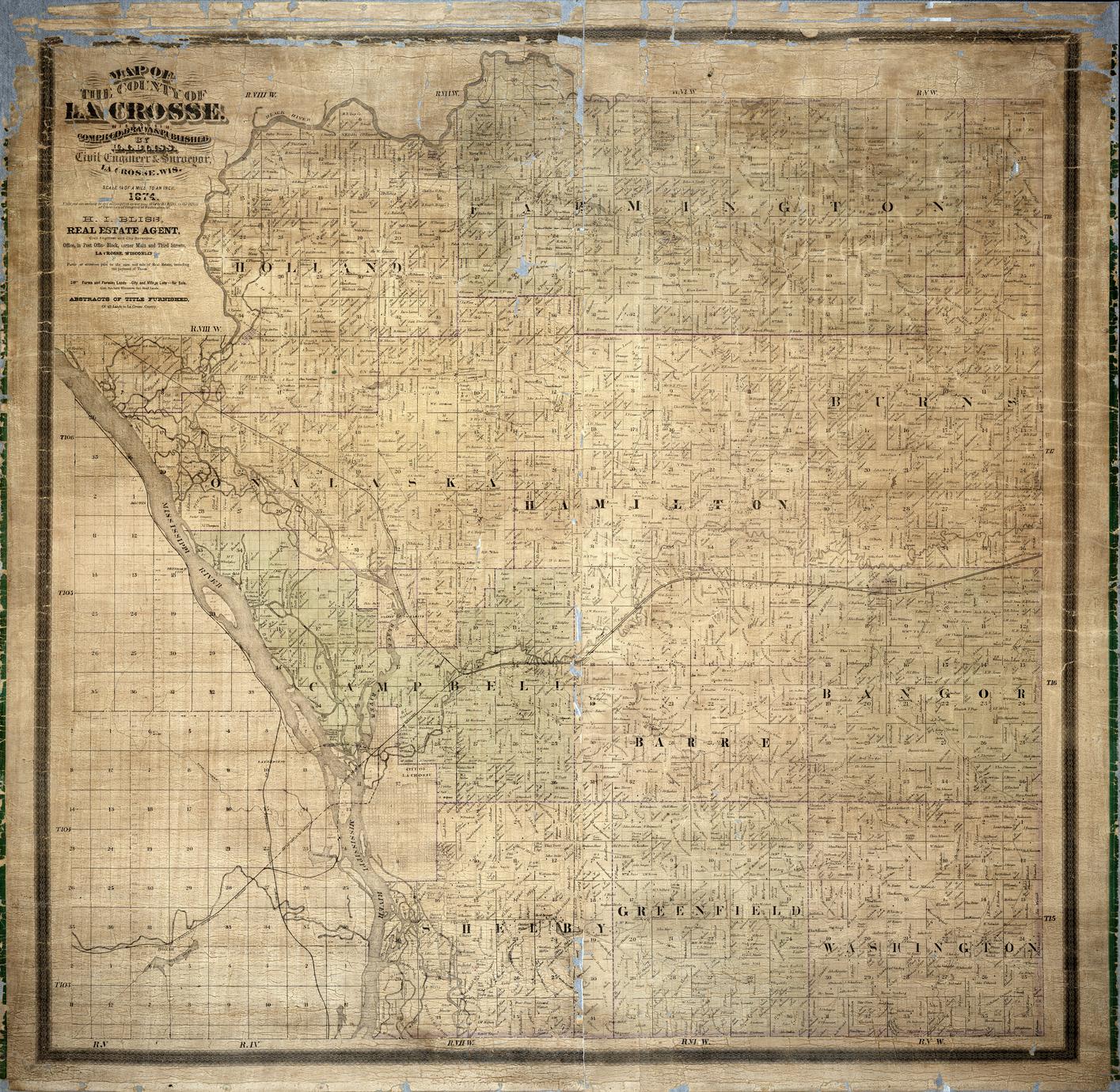
Author:
Bliss and Spear
Creator:
Henry I. Bliss 1831?-1896
Description:
Shows plats for the cities of La Crosse and La Crescent and surrounding area. Also shows railroad lines. No scale given.
Author:
County Highway Commissioner
Creator:
La Crosse County, Wisconsin. Highway Department
Description:
July 2, 1927. La Crosse County Highway Committee J. L. Ash, R. W. Davis, F. L. Goddard, H. A. Jolivette, William Keppel, La Crosse County Highway Commissioner John Hintgen. Shows United States, state, county and town roads indicating the pavement surface, townships, towns, Tourist camps, schools, creeks, rivers, railroads
Scale 1:63,360; 1 inch = 1 mile
Map / 74 x 76 cm / Black and white
Map / 74 x 76 cm / Black and white
Creator:
United States. Post Office Department
Description:
La Crosse County Wisconsin 369. H. P. February 24,1910. Includes hand coloring for state trunk routes. Shows United States postal routes for La Crosse County. Stations include: Bangor R R 1-3, Holmen R R 1-2, La Crosse R R 1-3, Midway, Mindoro R R 1-2, Onalaska, Rockland, St Joseph, West Salem R R 1-3. Also shows Post offices, discontinued post offices, churches, schools, and houses
Scale circa 1:63,360; 1 inch = 1 mile
Map / 79 x 85 cm / Color / Hand colored
Map / 79 x 85 cm / Color / Hand colored
Author:
City Engineers Department
Creator:
La Crosse (Wis.). City Engineers Department
Description:
Drawn 1952, revised September 1964. Shows residential, multiple dwelling, local business, commercial, light industrial, heavy industrial and special multiple dwelling zonings. Also shows city streets, parks, cemeteries, schools, hospitals, churches, fire stations, sewage treatment plant, La Crosse Home for Children, YMCA, public library, State Teachers College, State Training School, railroads, railroad depots, Interstate Fair Grounds, city hall, court house, US Bureau of Fisheries, City Water Works, county jail, swimming pool
Includes index of streets. Scale 1 inch = 1,000 feet
Map / 73 x 35 cm on sheet 77 x 50 cm / Black and white
Map / 73 x 35 cm on sheet 77 x 50 cm / Black and white
Author:
Andrew B. Graham, Photo-Lithographer
Creator:
Thompson, W. A.
Description:
Shows areas of the Mississippi River to be filled and dredged for a harbor at La Crosse, Wisconsin. United States Engineer Office, Rock Island, Illinois January 11, 1897. To accompany my letter of this date, W. R. King, Lieutenant Colonel of Engineers, United States Army
H Doc 210’ 54 2
Includes old and present Black River channels, old and present La Crosse River channels, City of La Crosse from La Crosse St. through Jay street, Jo Lynn Slough, Wade House, Little French Slough, Grand Island, Bates Island. Also indicates projected channels, shore protection, low dams built and projected, high dams built and projected
Scale 1:7200
Map / 34 x 49 cm / Color
Map / 34 x 49 cm / Color
Creator:
Henry I. Bliss 1831?-1896
Description:
Includes street index. "Entered according to Act of Congress in the year 1893 in the Office of Library of Congress" Shows ward boundaries in red, streets, railroads, cemeteries, Grand station crossing, road to French Island, depots, Lake Park, Inter-State Fair Grounds and trotting park
Scale 1:24,000; 2000 feet = 1 inch
Map / 24 x 37 cm / on sheet 32 x 46 cm
Map / 24 x 37 cm / on sheet 32 x 46 cm
Creator:
Henry I. Bliss 1831?-1896
Description:
Map shows city streetcar routes and the railroads serving La Crosse. Map shows Chicago, Milwaukee and St. Paul Railroad, Southern Minnesota Railroad and Dubuque Division, Horse Rail Road , Oak Grove Cemetery, Fair Grounds and Trotting Park , Green Bay and Minnesota Railroad ,Shooting Park
Scale 1:7200; 1 inch=2000 feet
Map / 36 x 24 cm / Black and white
Map / 36 x 24 cm / Black and white
Author:
La Crosse, Wisconsin
Description:
Insets (overview of the three maps), Plat of E.D. Clinton and Blackwell’s addition to the City of La Crosse. Wards (1-10) shaded in color. Includes Alphabetical index to list of plats, List of plats in order of date of record, Plats not upon record
Shows names of additions, streets, railroads, roundhouses, Burlington Club House, sawmills, schools, mills, churches, Hanford Oil Company Warehouse, banks, post office, boarding houses, foundry shops, street car stables, cemeteries, Trotting Park, Concordia Social Hall, breweries, gas works, cooper shops, tanneries, La Crosse Plow Works, Electric Light and Power Co.,carriage factory, flour mills, hotels, pork packing houses, court house, jail, La Crosse Business College, La Crosse Cracker Company, marble works, library, market square, Boiler Works, City Water Works, pump house, dry house, public square, soda water factory, hospital, convent, woolen mill, armory, Saint. Michaels Orphan Asylum, shooting park. Scale 1:9,600; 1 inch = 800 feet
Map / on sheet 93 x 54 cm. / color
Map / on sheet 93 x 54 cm. / color
Author:
Bliss and Spear
Description:
Includes Alphabetical index to list of plats, List of plats in order of date of record, plats not upon record. Shows plats including plat name and number and some lot owner’s names. Scale 1:6,000; 1 inch = 500 feet
Author:
La Crosse, Wisconsin
Description:
Maps Includes: List of plats in order of date of record (map 2), Laws which vacate plats (map 3), Plats not shown as upon the county records (map 3), Description and contents of the tracts of land (map 3), Alphabetical index to list of plats (map 3). Plat additions outlined in red. Insets [overview of the three maps], Map of B.S. Reppy’s outlots to the Village of La Crosse (map 2), Plat of E.D. Clinton and Blackwell’s addition to the City of La Crosse (map 3). Shows names of additions, streets, railroads, roundhouses, mills, schools, churches, pump house, dry house, post office, boarding houses, banks, foundry and machine shops, railroad depots, saw mills, hotels, street car stable, Oak Grove Cemetery, Trotting Park, Concordia Social Hall, Gas Works, G. Zeisler’s Brewery, cooper shop, tanneries, La Crosse Plow Works, threshing machine factory, carriage factory, court house, jail, electric light tower, American Express Office, pork packing houses, La Crosse Business College, Opera House, La Crosse Cracker Company, flouring mills, wagon shops, Marble Works, City Scales, Boiler Works, City Water Works, soda water factory, C and J Michels Brewery, armories, woolen mills, convent, hospital, G. Heilemans Brewery, Gunds Empire Brewery, shooting park. Scale 1:6,000; 1 inch = 500 feet
Map / 3 maps on sheets 72 x 107 cm / Black and white
Map / 3 maps on sheets 72 x 107 cm / Black and white
Author:
Chamber of Commerce
Creator:
Chamber of Commerce (La Crosse, Wis.)
Description:
Map dated 1926, date on title panel 1927. Pictures of La Crosse buildings on the back. Includes sketch map of Mississippi River valley on back. Highways in red. Includes index. This map has much tourist information. It lists points of interest, has area photos, and a short history of the area. Puts great emphasis on the Great Winnesheik Refuge. Includes Four Mile House, Cold Springs, Grand Crossing Station, Coleman Slough, French Slough, Copeland Park, Freight depot, Jolynn Slough, Taylors Island, Bates Island, Pettibone Park, Isle La Plume, Isle a Plume Slough, City Water Works, Oak Grove Cemetery, Hixon Reserve, Golf Links, Inter State Fair Grounds, Riverside Park, Market Square, Court House Square, Burns Park, Cameron Park, High School, Catholic Cemetery, Hogan School, West Avenue Play Field, Fire Stations, Railroad depots, North American Telegraph Company, Postal Telegraph Company, Western Union Telegraph Company, La Crosse Telephone Company Station, AT&T Company, Wisconsin Telephone Company, Northwestern Bell Telephone Company, Tri State Telephone and Telegraph Company, La Crosse Inter Urban Telephone Company, Grandview Hospital, La Crosse Hospital, Lutheran Hospital, Saint Francis Hospital, Saint Ann Annex, Saint Camillus, Batavian National Bank, Exchange State Bank, Gateway City Bank, La Crosse Trust Company, National Bank, Security Bank, State Bank, Myrick Park, Forest Avenue Park, Jewish Cemetery, North Side Cemetery, Community House, Tourist Camp, Bathing Beach, Vocational School, Municipal Bath House, United States Weather Bureau, State Normal School and Physical Education Building, Fish Hatchery, Logan Junior High School, High School Manual Training, City Hall, YMCA, Public Library, Chamber of Commerce, Court House, Play Grounds, Post Office, La Crosse River old and new channels.
Map / 65 x 55 cm / Color
Map / 65 x 55 cm / Color
Author:
Brice and Smith
Creator:
George W. Brice
W. C. Smith
W. C. Smith
Description:
Inset: "List of plats in order of date of record, 1851-1889" Lists township and section numbers outside municipality, housing additions and subdivisions and plat owners outside municipality
Shows voting wards, street names, cemeteries, railroads, parks, schools, churches, Island Mill Lumber Company, planning mill, masonic hall, depot, Nichols Lumber Company's sawmill, wagon bridge, road to French Island, Onalaska brewery Scale 1:3,600; 300 feet = 1 inch
Author:
Brice and Smith
Description:
Plat map : 1890
Shows township outlines, railroads, and rural land owner's names. Scale 1:2,534,400; 1 inch = 40 miles
Map / On sheet 126 x 127 cm / Color
Shows township outlines, railroads, and rural land owner's names. Scale 1:2,534,400; 1 inch = 40 miles
Map / On sheet 126 x 127 cm / Color
Creator:
Henry I. Bliss, 1831?-1896
Description:
Shows township outlines, railroads, roads and rural land owner's names. Post office locations are written in.
Scale 1:47,520; 1 inch = 3/4 mile
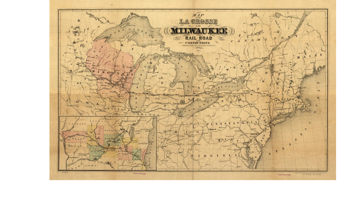
Author:
La Crosse and Milwaukee Railroad Company
Creator:
Joseph Hutchins Colton
La Crosse and Milwaukee Railroad Company
La Crosse and Milwaukee Railroad Company
Description:
Map of the northeastern and north-central United States indicating major drainage, larger cities, state boundaries, and the railroad network.
Scale ca. 1:2,150,000. LC Railroad maps, 440. Description derived from published bibliography. Inset: [Enlarged map of central Wisconsin] 20 x 37 cm. Available also through the Library of Congress Web site as a raster image.
Part of Library of Congress Geography and Map Division
Scale ca. 1:2,150,000. LC Railroad maps, 440. Description derived from published bibliography. Inset: [Enlarged map of central Wisconsin] 20 x 37 cm. Available also through the Library of Congress Web site as a raster image.
Part of Library of Congress Geography and Map Division
Description:
Prime meridians: Greenwich, Washington. Scale 1:1,267200; 1 inch = 20 statute miles
Map / Hand colored / 38 x 36 cm
Map / Hand colored / 38 x 36 cm
Map showing the location of sawmills at Onalaska, North La Crosse and La Crosse, Wisconsin,1850-1910
Description:
Shows the location and gives names of the sawmills along the Black River and Mississippi River from Onalaska to La Crosse between the years 1850 to 1910.
Map / 2 maps 51 x 41 cm / Black and white.
Map / 2 maps 51 x 41 cm / Black and white.
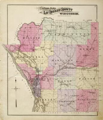
Description:
Maps of La Crosse and La Crosse County, Wisconsin, in the online collections of the Wisconsin Historical Society. Among the results are some manuscript maps from the Henry I. Bliss collection titled Collection of Manuscript Maps of the City of La Crosse, La Crosse County, and Surrounding Areas. Bliss who settled in La Crosse in 1856 and served as a real estate dealer, city and county surveyor, and Civil Engineer of La Crosse.
Half of the Bliss collection are plats and maps of La Crosse showing additions, cemeteries, railroads, water works, and proposed roads. Others are township maps in La Crosse County showing natural features, roads, and landownership. Also shown are a few other villages, including Stoddard, Salem, and Onalaska.
Half of the Bliss collection are plats and maps of La Crosse showing additions, cemeteries, railroads, water works, and proposed roads. Others are township maps in La Crosse County showing natural features, roads, and landownership. Also shown are a few other villages, including Stoddard, Salem, and Onalaska.

Description:
This group of material includes maps and atlases of La Crosse County of a variety of types, including plat (rural land ownership), highway, soil, topographic; city of La Crosse (Wisconsin) including zoning, parks, and street; other La Crosse County municipalities; and representative pre- and post-lock and dam charts and maps of the Upper Mississippi River. The date range of this map collection is approximately 1854-1987 and explores the rich history of the area from the days of logging to the post-lock and dam system on the Mississippi River.
This project brings together in an online environment content that is located physically at three separate institutions: the La Crosse Public Library, Murphy Library at the University of Wisconsin-La Crosse and the Wisconsin Historical Society.
Maps and Atlases of La Crosse County, Wisconsin, and the Upper Mississippi River is a collaborative project completed by the UWDCC and the La Crosse Public Library. Digitization of Maps and Atlases of La Crosse County, Wisconsin, and the Upper Mississippi River was funded, in part, through a 2008 Library Services and Technology Act (LSTA) grant. LSTA is governed by the Institute of Museum and Library Services (IMLS) which is the primary source of federal support for the nation's 122,000 libraries and 17,500 museums. The Institute's mission is to create strong libraries and museums that connect people to information and ideas.
Maps and Atlases of La Crosse County, Wisconsin, and the Upper Mississippi River is a collaborative project completed by the UWDCC and the La Crosse Public Library. Digitization of Maps and Atlases of La Crosse County, Wisconsin, and the Upper Mississippi River was funded, in part, through a 2008 Library Services and Technology Act (LSTA) grant. LSTA is governed by the Institute of Museum and Library Services (IMLS) which is the primary source of federal support for the nation's 122,000 libraries and 17,500 museums. The Institute's mission is to create strong libraries and museums that connect people to information and ideas.
Creator:
Henry I. Bliss et al.
Minnesota & La Crosse Plank Road Company
Minnesota & La Crosse Plank Road Company
Description:
The articles of incorporation and a map of the Minnesota and Plank Road Company filed with the State of Minnesota that planned to build two toll roads over the Mississippi River connecting the city of La Crosse to points west in Minnesota. Proposed railroad lines are also included on the map in red.
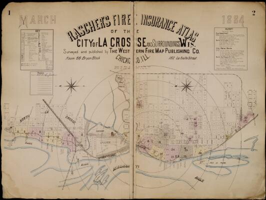
Author:
Western Fire Map Publishing Co.
Creator:
Western Fire Map Publishing Co.
Description:
Includes street and building indexes. Includes updates through October 1885.
Key: brick and iron chimneys, forges, furnaces, hydrants, engines, steam pumps, cisterns, fire alarm boxes, steam boilers, stand pipes, fire escapes, water pipes, fire plugs, elevators, hoists, windows, dwellings, stone or brick basement, buildings (frame, brick, stone, iron, brick-lined, tin, iron-clad), wall and rood type.
Shows: distance from court house, railroads, railroad depot, emigrant rooms and roundhouses, streets, rivers, churches, warehouses, hotels, factories, breweries, grain elevators, lumber yards, saw mills, shingle mills, planning mills, flour mills, grain mills, liveries, stables, cemeteries, fire stations, banks, omnibus lines, ice houses, schools, pork packing companies, threshing machine factories, pump factories, foundries, roller rinks, banks, hay market, public squares, boarding houses, saloons.
Individual businesses listed include: Chicago, Milwaukee and St. Paul Railroad, Chicago and North Western Railroad, Green Bay and Western Railroad, La Crosse Street Railway, Chicago and La Crosse Trunk Line, St. Rose Convent, City Water Works, C.L. Coleman Lumber Company, P.S. Davidson Lumber Company, White Collar Mill, Davis, Medary and Platz Company, A.A. Freeman Company Flour Mill, M. Funk Boiler Works, John Gund Brewing Company, Empire Brewery, J. Heileman City Brewery, N.B. Holway Lumber Company, La Crosse County Courthouse and Jail, La Crosse Lumber Company, McDonald Brothers Lumber Company, McDonald Brothers Towboat Supply Company, C. and J. Michel Brewery, La Crosse Brewery, C.H. Nichols and Company, Onalaska Brewery, John Paul Lumber Company, Sawyer and Austin Lumber Company, Segelke Kohlhaus and Company, A. Strow and Company, J. Vincent Lumber Company, George Zeisler Plank Road Brewery, La Crosse Brush Electric Light and Power, La Crosse Gas Light Company, Island Mill, La Crosse Soap Company, La Crosse Woolen Mill, Eagle Brewery (Bartl), H. Goddard Lumber Company, R.M. Mooer Lumber Company, G.H. Pierce Planning Mill, Princess Roller Skating Rink, La Crosse Plow Works, A.S. Trow and Company Saw Mill, Doud, Son and Company Cooper Shop, Polleys Brothers Lumber Yard, Central Roller Rink, City Mills (Yeo and Clark), City Mills, La Crosse Wallace Carriage Company, John Ulrich Washing Machine Factory, YMCA, Masonic Hall, Light Guard Hall, Post Office, La Crosse Linseed Oil Company, Voight and Ritter Carriage and Wagon Works, La Crosse Cracker Factory, La Crosse Knitting Factory, Sierman, Techmer and Company Oatmeal Mill, Western Wisconsin Iron Works, La Crosse Furniture Association, William Listman Flour Mill, Torrance and Son Foundry, Pioneer Foundry (John James), City Plow Works, La Crosse Ice Company, West Wisconsin Vinegar Works.
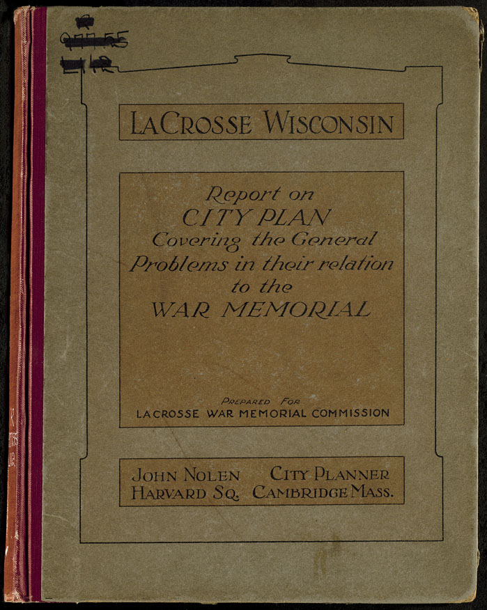
Author:
J. Nolen
Creator:
Nolen, John, 1869-1937
La Crosse War Memorial Commission (La Crosse, Wis.)
La Crosse War Memorial Commission (La Crosse, Wis.)
Description:
The first comprehensive city plan for La Crosse is this effort by John Nolen, noted landscape architect and city planner. Nolen is credited with forming the city park system in La Crosse and was hired by the La Crosse War Memorial Commission to do this plan. In part, it was intended to honor veterans of the Great War, or more commonly known now as World War I. This report accompanies a set of maps by Nolen which are also digitized.
At head of title: La Crosse, Wisconsin. "Prepared for La Crosse War Memorial Commission"--Cover
106 leaves, [11] leaves of plates : ill. (some col.) ; 29 cm.
At head of title: La Crosse, Wisconsin. "Prepared for La Crosse War Memorial Commission"--Cover
106 leaves, [11] leaves of plates : ill. (some col.) ; 29 cm.
Author:
United States. Bureau of Soils
Description:
Field operations, Bureau of Soils, 1911. Map shows distribution of soil types by color and symbol. Soils surveyed by W. J. Geib and Clarence Lounsbury of the United States Department of Agriculture, and T. J. Dunnewald of the Wisconsin Geological and Natural History Survey. Scale Scale 1:63,360; 1 inch = 1 mile
Map / 66 x 67 cm / Color
Map / 66 x 67 cm / Color
Author:
George A. Ogle & Company
Creator:
George A. Ogle & Co.
Description:
A plat book of La Crosse County, Wisconsin, 1906
Description:
January, 1965 - R.C.J. Base map traced by DJA, October 1960; Base map revised by RCJ, November 1961. Shows block and lot dimensions and numbers for Residence, Business and Industrial Districts.
Scale 1 inch = 200 feet
Author:
Wisconsin. Geological Survey
Creator:
Wisconsin. Geological Survey
Description:
Relief shown by contours and spot heights. Shows United States, state, county and local highways and roads, schools, North Bend, creeks, lakes, rivers, Decorah Prairie, Maiden Rock, Butman Corners, Cox Hill, Wittville, Council Bay, parks, bluffs, railroads, Wadels Hill, Twin Peaks, Upper Burns, Walness Hill, chutes, sloughs, County Asylum, valleys, ridges, cemeteries, Grand Crossing, Cold Springs, islands, Poor Farm, churches
Scale 1:62,500
Map / 79 x 74 cm / Color
Map / 79 x 74 cm / Color
Author:
Wisconsin State Planning Board
Creator:
Wisconsin. State Planning Board
Description:
Compiled from aerial photographs.
Scale 1:12,000; 1 inch = 1,000 feet
Map / 92 x 94 cm / Black and white
Scale 1:12,000; 1 inch = 1,000 feet
Map / 92 x 94 cm / Black and white
Author:
Corps of Engineers
Creator:
United States. Army. Corps of Engineers. St. Paul District
Description:
Maps show shoreline at normal pool elevations, topography of adjacent bottom lands, navigation aids, submerged or exposed structures, bridge clearance, and 1973 or later soundings. Published between 1938 and 1942. Only Pool 8 digitized. Black line print. Scale 1:5000
83 maps / 66 x 99 cm each
83 maps / 66 x 99 cm each
Author:
Corps of Engineers
Creator:
United States. Army. Corps of Engineers
Description:
Buildings and points of interest shown pictorially-Upper Mississippi River nine-foot channel. "February 1959" Scale 1:2,500,000
Map / Color / 46 x 61 cm
Map / Color / 46 x 61 cm
Author:
Morgan, Lodge and Fisher, printers
Creator:
Cumings, Samuel
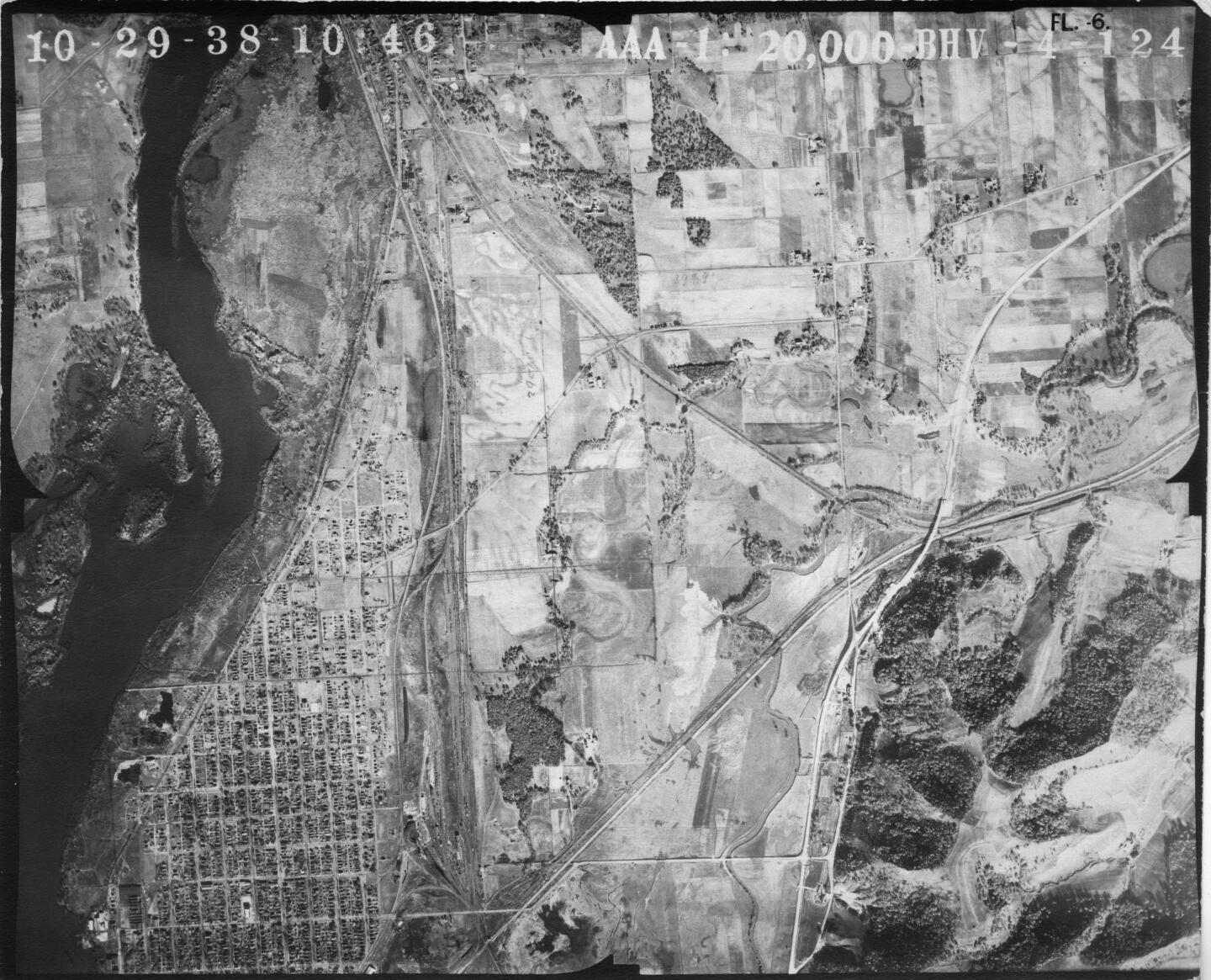
Description:
The Wisconsin Historic Aerial Image Finder provides free online access to over 38,000 aerial photographs of Wisconsin from 1937-41. These photographs were originally acquired by the US Department of Agriculture. As part of a three-year project funded by the Ira and Ineva Reilly Baldwin Wisconsin Idea Endowment at the University of Wisconsin-Madison, these photographs were scanned, indexed, and made web-accessible through a map-based interface. These photographs are available for download by any user without fee or use restrictions. Collaborators on the Wisconsin Historic Aerial Image Finder project include the Wisconsin State Cartographers Office, The Arthur H. Robinson Map Library, the University of Wisconsin Digital Collections Center, and the Wisconsin Department of Transportation.
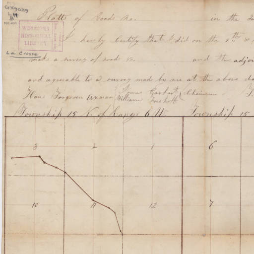
Author:
General Land Office (U. S.)
Creator:
Board of Commissioners of Public Lands (Wis.)
Description:
The field notes and plat maps of the public land survey of Wisconsin are a valuable resource for original land survey information, as well as for understanding Wisconsin's landscape history. The survey of Wisconsin was conducted between 1832 and 1866 by the federal General Land Office. This work established the township, range and section grid; the pattern upon which land ownership and land use is based. The survey records were transferred to the Wisconsin Board of Commissioners of Public Lands after the original survey was completed.
Author:
Wright's Directory Company
Description:
Includes street index. Points of interest include parks, railroads, cemeteries, the bridge over Black River at Copeland Park, Burns Park, Cameron Park,Copeland Park, Inter State Fair Grounds, Myrick Park, State Normal School, Riverside Park, Spence Park, Oak Grove Cemetery, La Crosse River old and new channels, Convent, Hospital, John Gund Brewing Company. Scale not given.
Map / 96 x 39 cm / b&w
Map / 96 x 39 cm / b&w
Author:
Arthur J. Rabuck
Creator:
La Crosse (Wis.). City Plan Commission
Description:
Adopted by the Common Council August 12th, 1938. Shows residence, multiple dwelling, local business, commercial, light industrial, heavy industrial zonings. Also shows ward boundaries, city streets, cemeteries, schools, fire stations, churches, railroads, railroads depots, Northern States Power Generating Plant, county jail, city water works, court house, federal building, Salvation Army, vocational school, public libraries, parks, training school, State Normal School, Inter State Fair Grounds, swimming pool, bath house, Market Square, hospitals and clinics, Saint Joseph’s Home for the Aged, Saint Francis School for Nursing, disposal plant, Viterbo College, Saint Rose Convent
Scale 1,066 feet =1 inch
Map / on sheets 28 x 41 cm. / black and white / 3 map
Map / on sheets 28 x 41 cm. / black and white / 3 map